Scroll Top

Moʻolelo Monday

Moʻolelo Monday

On the first Monday of the month a traditional or modern moʻolelo depicting the jculture, values, language or traditions of Hawaiʻi, will be shared through a virtual platform. These mo‘olelo promote literacy within the classroom and home, and encourage ʻohana to read and learn together. Moʻolelo are shared by staff and guest storytellers.

MOʻOKALALEO

In the 1820’s, Kauikeaouli, Kamehameha III was the catalyst for the rise of literacy in Hawaiʻi. He stated, “ ʻO Koʻu Aupuni, he Aupuni palapala koʻu.  My kingdom shall be a kingdom of literacy”. Within our moʻokalaleo, we share a literacy component that extends our moʻolelo journey. 

Geology of Koʻolau Mountain Range
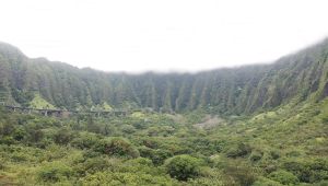
As you gaze down from the Nuʻuanu Pali you are looking primarily at the ahupuaʻa or land division of Kāneʻohe. Hawaiian land divisions known as ahupuaʻa stretched from the mountains to the sea and allowed people living within an ahupuaʻa in ancient days to have access to all the resources needed for their survival. Also in this view plane is part of the ahupuaʻa of Kailua visible to the right and Heʻeia and beyond to Kualoa can be seen stretching out below the Koʻolau mountains, to the left all these lands are framed by the Koʻolau mountains on one side and the ocean on the other.

The Ko’olau mountains in this area are famous for their pali or steep cliffs, lush and vividly green, and often with beautiful waterfalls flowing down their slopes. The view from the Nuʻuanu Pali is of a mature landscape within the Ko’olau mountains. It is the remains of one of the enormous shield volcanoes that built Oʻahu. The Koʻolau is approximately 2 to 3 million years old and is built layer upon layer of lava flows. The Koʻolau volcano was once much higher and much more massive than it is currently. It was once shaped like a shield turned on its side. Geologists estimate that it formerly stood at least 9,000 feet above sea level.

The highest peak in the Koʻolau, Konahuanui Peak, is only 3,150 feet in elevation. Such a tremendous amount of volcanic material has been carried away over time. Erosion primarily by rain-forming waterfalls and streams ate away at the volcano, carving huge valleys into its sides and creating flatlands below. This area was also part of an enormous submarine landslide that removed an immense amount of material from the northeast flank of the Koʻolau volcano. A catastrophic landslide occurred approximately 200,000 years ago and is responsible for carrying approximately 40% of the Koʻolau volcano as far as 150 miles along the ocean floor. Scientists have identified this event as one of the largest landslides on earth. The land that was left behind has been further eroded away forming the view before you. 

In the story of Keaomelemele, there is a cultural explanation as to the geological creation of Nuʻuanu valley as well as the Koʻolau mountain range. Within the story, it talks about Keaomelemele living in Waolani, in Nuʻuanu and mastering hula within a week’s time. She then becomes a kumu hula to her sister Paliuli and her companions. It is said that after a week long of dancing together as a group, O’ahu starts to shake and reverberate and the whole Konahuanui mountain crashes open, creating a huge cleft, separating Waolani from Konahuanui and forming the valley of Nu’uanu.
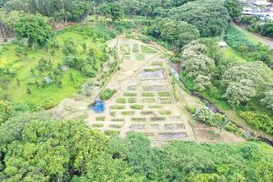
The wind is another form of erosion that is dominant in this area. The Pali lookout is a wind gap in the Ko’olau mountains that were created by erosion as two valleys lying back-to-back were eroded until they partially connected. The wind gap funnels the North East trade winds that blow onto the windward side of the island through it, creating the famous strong Pali winds. Enjoy the beauty of this land and the cool refreshing winds of the Pali. 

3

Leave a comment

You must be logged in to post a comment.